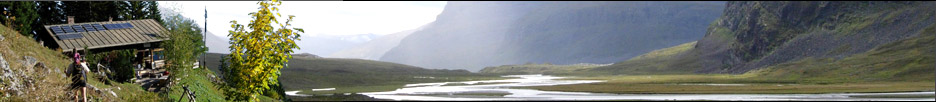


»Nøstebu Turistforeningshytte« östlich von Todal
| Höhe: | 840m | |||||||||
| Eigner: | Trondhjems Turistforening | |||||||||
| Geokoordinaten: | 62°48'5''N, 9°0'56''O
UTM: X 500793.5, Y 6963462.2, Zonenfeld 32 V |
|||||||||
| Aliase: | Nauståbu Turistforeningshytte östlich von Todal Nostebu Turistforeningshytte östlich von Todal Naustabu Turistforeningshytte östlich von Todal |
|||||||||
| Angebot: | ||||||||||
| Galerie: | Noch keine Bilder verfügbar. |
|||||||||
| Links: |
|
Letzte Bearbeitung:
Dienstag, 11. August 2015, 18:46 Uhr
Seitenaufrufe: 955
Seitenaufrufe: 955