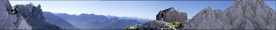


Birch Mountain
GPS-Tracks
Folgende GPS-Tracks tangieren diesen Punkt (hier einen Track beginnen):
| Name | Infos | Länge | Höhenm. | Typ |
|---|---|---|---|---|
| Es konnten keine GPS-Tracks gefunden werden. | ||||
Benachbarte Hütten
Im Umkreis von 20km, alle Entfernungen Luftlinie / real, alle Hütten.
| Name | Infos | Entf. | Richt. | Optionen |
|---|---|---|---|---|
| Es konnten keine Hütten gefunden werden. | ||||
Orte in der Nähe
Im Umkreis von maximal 20 km, alle Entfernungen Luftlinie / real, alle Orte.
| Name | PLZ | Entf. | Richt. | Optionen |
|---|---|---|---|---|
| Fish Springs | USA-? | 14.7km | O | Karte |
| Big Pine | USA-? | 16.2km | NO | Karte |
| Aberdeen | USA-? | 17.4km | OSO | Karte |
| Elna (historical) | USA-? | 17.6km | ONO | Karte |
| Monola | USA-? | 18km | ONO | Karte |
| Zurich | USA-? | 19.5km | NO | Karte |
Achtung: Die Lage der Städte und damit auch die Entfernung ist teils recht ungenau und sollte nur als grober
Anhaltspunkt angesehen werden. Zudem sind die Angaben lediglich als bewohnte
Orte zu verstehen.
Gipfel im Umkreis (Auswahl)
Im Umkreis von maximal 20km, alle Entfernungen Luftlinie / real, alle Gipfel.
| Name | Infos | Höhe | Entf. | Richt. | Optionen |
|---|---|---|---|---|---|
| Ed Lane Peak | 4138m | 1.6km | W | Karte | |
| The Thumb | 4071m | 2.7km | WNW | Karte | |
| Mount Bolton Brown | 4112m | 2.7km | WSW | Karte | |
| Mount Prater | 4106m | 3.2km | SW | Karte | |
| Mount Tinemaha | 3816m | 3.5km | SO | Karte | |
| Balcony Peak | 4230m | 4.3km | WNW | Karte | |
| Kid Mountain | 3615m | 4.4km | NNW | Karte | |
| Disappointment Peak | 4242m | 4.5km | WNW | Karte | |
| Middle Palisade | 4271m | 4.6km | WNW | Karte | |
| Split Mountain | 4285m | 4.6km | SSW | Karte | |
| Norman Clyde Peak | 4243m | 5km | WNW | Karte | |
| Norman Clyde Peak | 4223m | 5.1km | WNW | Karte | |
| Split S1 | 4190m | 5.4km | SSW | Karte | |
| Mount Williams | 4152m | 5.6km | WNW | Karte | |
| Palisade Crest | 4131m | 6.7km | WNW | Karte | |
| Cardinal Mountain | 4083m | 7km | S | Karte | |
| Mount Jepson | 4081m | 7.4km | WNW | Karte | |
| Mount Alice | 3541m | 8km | NNW | Karte | |
| Mount Sill | 4314m | 8.3km | WNW | Karte | |
| Temple Crag | 3962m | 8.4km | WNW | Karte | |
| Mount Gayley | 4118m | 8.6km | WNW | Karte | |
| Vennacher Needle | 3961m | 8.6km | SW | Karte | |
| Polemonium Peak | 4292m | 9km | WNW | Karte | |
| Starlight Peak | 4328m | 9.3km | WNW | Karte | |
| Saddlehorn | 3722m | 9.6km | SW | Karte | |
| Thunderbolt Peak | 4268m | 9.7km | WNW | Karte | |
| North Palisade | 4341m | 9.9km | WNW | Karte | |
| Dumbbell Peak | 3926m | 9.9km | WSW | Karte | |
| Observation Peak | 3768m | 10.4km | WSW | Karte | |
| Goodale Mountain | 3898m | 10.5km | SSO | Karte | |
| Mount Winchell | 4196m | 10.5km | WNW | Karte | |
| Mount Ruskin | 3938m | 10.5km | SW | Karte | |
| Mount Shakspere | 3711m | 10.6km | W | Karte | |
| Mount Robinson | 3952m | 10.7km | WNW | Karte | |
| Striped Mountain | 4017m | 10.8km | S | Karte | |
| Mount Agassiz | 4234m | 11.4km | WNW | Karte | |
| Columnbine Peak | 3859m | 11.4km | WNW | Karte | |
| Sky Haven | 3931m | 11.6km | NW | Karte | |
| Two Eagle Peak | 3952m | 11.8km | WNW | Karte | |
| Pinchot N1 | 4043m | 11.8km | S | Karte | |
| Isosceles Peak | 3755m | 11.8km | WNW | Karte | |
| Aperture Peak | 4043m | 11.8km | WNW | Karte | |
| Columbine Peak | 3856m | 12km | WNW | Karte | |
| Gendarme Peak | 4039m | 12.4km | WNW | Karte | |
| Mount Pinchot | 4113m | 12.9km | S | Karte | |
| Observation SW3 | 3657m | 13km | WSW | Karte | |
| Picture Puzzle | 4055m | 13km | WNW | Karte | |
| Giraud Peak | 3843m | 13.1km | WNW | Karte | |
| Cloudripper | 4122m | 13.3km | WNW | Karte | |
| Windy Cliff | 3399m | 13.7km | WSW | Karte | |
| Chocolate Peak | 3561m | 13.9km | WNW | Karte | |
| Mount Wynne | 4017m | 13.9km | S | Karte | |
| Vagabond Peak | 4076m | 13.9km | NW | Karte | |
| Red Point | 3622m | 14.2km | SW | Karte | |
| Mount Ickes | 3942m | 14.5km | SSW | Karte | |
| Mount Goode | 3988m | 14.9km | WNW | Karte | |
| Marion Peak | 3877m | 15km | SW | Karte | |
| Mount Perkins | 3830m | 15.4km | SSO | Karte | |
| Crater Mountain | 3924m | 15.6km | S | Karte | |
| Peak 12,960+ "Trapezoid Peak" | 3950m | 15.6km | WNW | Karte | |
| Hurd Peak | 3730m | 15.7km | WNW | Karte | |
| Rambaud Peak | 3366m | 16km | W | Karte | |
| Arrow Peak | 3950m | 16.2km | SSW | Karte | |
| Mount Johnson | 3923m | 16.6km | WNW | Karte | |
| The Citadel | 3578m | 17.2km | WNW | Karte | |
| Langille Peak | 3663m | 17.7km | WNW | Karte | |
| Devils Crags | 3737m | 17.8km | W | Karte | |
| Pyramid Peak | 3895m | 17.8km | SSW | Karte | |
| Colosseum Mountain | 3795m | 17.8km | SSO | Karte | |
| Mount Cedric Wright | 3771m | 17.8km | S | Karte | |
| Mount Gilbert | 3995m | 17.9km | WNW | Karte | |
| Mount Woodworth | 3724m | 18.1km | W | Karte | |
| State Peak | 3847m | 18.4km | SW | Karte | |
| Wheel Mountain | 3894m | 18.8km | W | Karte | |
| Dougherty Peak | 3731m | 19.4km | SW | Karte | |
| Mount Thompson | 4113m | 19.5km | WNW | Karte | |
| Thompson NE1 | 4055m | 19.5km | WNW | Karte | |
| Window Peak | 3684m | 19.5km | SSW | Karte |
Download der Koordinaten
- Fugawi 3 (inkl. Umkreisdaten) (TXT)
- G7ToWin (inkl. Umkreisdaten) (CSV-Datei)
- GARtrip (inkl. Umkreisdaten) (TXT)
- Google Earth (inkl. Umkreisdaten) (KML Placemark)
- GPS Exchange Format (inkl. Umkreisdaten) (GPX)
- OziExplorer (inkl. Umkreisdaten) (Wegpunkte, v1.1)
Letzte Bearbeitung:
Unbekannt
Seitenaufrufe: 809
Seitenaufrufe: 809