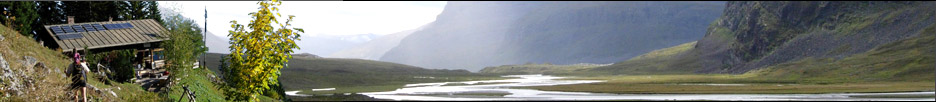


»Ada Pass Hut« Greymouth
GPS-Tracks
Folgende GPS-Tracks tangieren diesen Punkt (hier einen Track beginnen):
| Name | Infos | Länge | Höhenm. | Typ |
|---|---|---|---|---|
| Es konnten keine GPS-Tracks gefunden werden. | ||||
Benachbarte Hütten
Im Umkreis von 20km, alle Entfernungen Luftlinie / real, alle Hütten.
| Name | Infos | Entf. | Richt. | Optionen |
|---|---|---|---|---|
| Cannibal Gorge Hut Lewis Pass National Reserve | 3.1km | SW | Karte | |
| Old Anne Hut St. James Conservation Area | 7.5km | SO | Karte | |
| New Anne Hut St. James Conservation Area | 7.5km | SO | Karte | |
| Christopher Hut St. James Conservation Area | 8.6km | ONO | Karte | |
| Ada Cullers Hut St. James Conservation Area | 8.9km | ONO | Karte | |
| Bob's Hut Nelson Lakes National Park | 9.4km | NNO | Karte | |
| Pell Stream Hut Lewis Pass National Reserve | 9.7km | W | Karte | |
| Manson Nicholls Memorial Hut Lewis Pass National Reserve | 13.6km | W | Karte | |
| Thompson's Flat Hut Lake Daniell | 14.2km | WNW | Karte | |
| Rokeby Hut St. James Conservation Area | 14.2km | S | Karte | |
| East Matakitaki Hut Upper Matakitaki Valley | 15.1km | NO | Karte | |
| Lake Guyon Hut St. James Conservation Area | 16km | O | Karte | |
| Lucretia Hut Lake Sumner Conservation Park | 16.1km | SW | Karte | |
| Pool Hut | 16.5km | SO | Karte | |
| Burn Creek Hut Nelson Lakes National Park | 16.7km | N | Karte | |
| Brass Monkey Bivvy Lewis Pass National Reserve | 17.1km | SW | Karte | |
| Boyle Flats Hut Lake Sumner Conservation Park | 17.7km | S | Karte |
Orte in der Nähe
Im Umkreis von maximal 25 km, alle Entfernungen Luftlinie / real, alle Orte.
| Name | PLZ | Entf. | Richt. | Optionen |
|---|---|---|---|---|
| Maruia Springs | NZ-? | 13.2km | WSW | Karte |
| Springs Junction | NZ-? | 22.4km | W | Karte |
| Maruia | NZ-? | 23.9km | WNW | Karte |
Achtung: Die Lage der Städte und damit auch die Entfernung ist teils recht ungenau und sollte nur als grober
Anhaltspunkt angesehen werden. Zudem sind die Angaben lediglich als bewohnte
Orte zu verstehen.
Gipfel im Umkreis (Auswahl)
Im Umkreis von maximal 20km, alle Entfernungen Luftlinie / real, alle Gipfel.
| Name | Infos | Höhe | Entf. | Richt. | Optionen |
|---|---|---|---|---|---|
| Es konnten keine Gipfel gefunden werden. | |||||
Download der Koordinaten
- Fugawi 3 (inkl. Umkreisdaten) (TXT)
- G7ToWin (inkl. Umkreisdaten) (CSV-Datei)
- GARtrip (inkl. Umkreisdaten) (TXT)
- Google Earth (inkl. Umkreisdaten) (KML Placemark)
- GPS Exchange Format (inkl. Umkreisdaten) (GPX)
- OziExplorer (inkl. Umkreisdaten) (Wegpunkte, v1.1)
Letzte Bearbeitung:
Montag, 16. September 2013, 12:20 Uhr
Seitenaufrufe: 940
Seitenaufrufe: 940