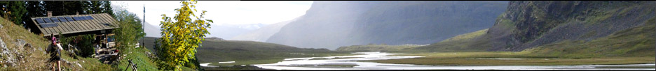


Refugi »Can Boi« in Deià
Europa
»
Spanien
»
Balearen
»
Serra De Tramuntana
»
Mallorca
Inseln » Balearische Inseln » Serra De Tramuntana
Inseln » Balearische Inseln » Serra De Tramuntana
GPS-Tracks
Folgende GPS-Tracks tangieren diesen Punkt (hier einen Track beginnen):
| Name | Infos | Länge | Höhenm. | Typ |
|---|---|---|---|---|
| Es konnten keine GPS-Tracks gefunden werden. | ||||
Benachbarte Hütten
Im Umkreis von 20km, alle Entfernungen Luftlinie / real, alle Hütten.
| Name | Infos | Entf. | Richt. | Optionen |
|---|---|---|---|---|
| Refugi d'es Cairats | 2.4km | SSO | Karte | |
| Grotte Cova de Ermita Guillem bei Valldemossa | 3km | SW | Karte | |
| Refugi de Muleta bei Port de Sóller | 6.4km | NNO | Karte | |
| Finca L'Ofre | 9.6km | O | Karte | |
| Refuge de Son Trias in Esporles | 10.8km | SW | Karte | |
| Oratoria de Nostra Senyora del Refugi | 12.7km | O | Karte | |
| Refuge Hospederia del Castillo de Alaro nördlich von Alaró | 12.8km | O | Karte | |
| Refugi Tossals Verds Mallorca | 15km | O | Karte |
Orte in der Nähe
Im Umkreis von maximal 20 km, alle Entfernungen Luftlinie / real, alle Orte.
| Name | PLZ | Entf. | Richt. | Optionen |
|---|---|---|---|---|
| Deyá | E-? | 1.1km | WNW | Karte |
| Valldemosa | E-? | 4.1km | SW | Karte |
| Sóller | E-? | 5.2km | ONO | Karte |
| Puerto de Sóller | E-? | 6.8km | NNO | Karte |
| Biniaritx | E-? | 7.9km | ONO | Karte |
| Buñola | E-? | 8.4km | SSO | Karte |
| Fornalutx | E-? | 8.6km | ONO | Karte |
| Sa Figuera | E-? | 9.6km | NO | Karte |
| La Esglayeta | E-? | 10.8km | SSW | Karte |
| Esporlas | E-? | 11.1km | SW | Karte |
| Son Espanyol | E-? | 12.6km | SSW | Karte |
| Establiments | E-? | 12.8km | SSW | Karte |
| Alaró | E-? | 12.9km | OSO | Karte |
| Bañalbufar | E-? | 13.1km | WSW | Karte |
| Son Sardina | E-? | 14.5km | S | Karte |
| Santa MarÃa | E-? | 14.9km | SO | Karte |
| Son Inglada | E-? | 16.5km | SSW | Karte |
| IndioterÃa | E-? | 16.6km | SSO | Karte |
| Pla de na Tesa | E-? | 16.9km | SSO | Karte |
| Sa Cabaneta | E-? | 17km | SSO | Karte |
| Marratxi | E-? | 17km | SO | Karte |
| Consell | E-? | 17.1km | OSO | Karte |
| Binisalem | E-? | 17.6km | OSO | Karte |
| Estellencs | E-? | 17.6km | WSW | Karte |
| Puigpuñent | E-? | 18.2km | SW | Karte |
| Son Rapinya | E-? | 18.3km | SSW | Karte |
| Pont d'Inca | E-? | 18.7km | SSO | Karte |
| Mancor del Valle | E-? | 18.9km | O | Karte |
| Creu Vermella | E-? | 19.1km | SSO | Karte |
| Escorea | E-? | 19.2km | ONO | Karte |
| Lloseta | E-? | 19.2km | O | Karte |
Achtung: Die Lage der Städte und damit auch die Entfernung ist teils recht ungenau und sollte nur als grober
Anhaltspunkt angesehen werden. Zudem sind die Angaben lediglich als bewohnte
Orte zu verstehen.
Gipfel im Umkreis (Auswahl)
Im Umkreis von maximal 20km, alle Entfernungen Luftlinie / real, alle Gipfel.
| Name | Infos | Höhe | Entf. | Richt. | Optionen |
|---|---|---|---|---|---|
| Tex | 1062m | 2.2km | SO | Karte | |
| Puig de l’Ofre | 1093m | 10.6km | O | Karte | |
| Puig de na Franquesa | 1067m | 11.4km | ONO | Karte | |
| Puig de sa Rateta | 113m | 12.2km | ONO | Karte | |
| Puig de Castell d'Alaro | 824m | 12.7km | O | Karte | |
| Penya de Migdia | 1356m | 13km | ONO | Karte | |
| Puig Major | 1445m | 14.4km | ONO | Karte | |
| Puig de ses Vinyes | 1108m | 15.5km | ONO | Karte | |
| Puig des Tossals Verds | 1118m | 15.5km | ONO | Karte | |
| Puig de ses Bassetes | 1212m | 18km | ONO | Karte | |
| Puig Galatzo | 1025m | 18.5km | WSW | Karte | |
| Massanella | 1348m | 18.6km | ONO | Karte |
Download der Koordinaten
- Fugawi 3 (inkl. Umkreisdaten) (TXT)
- G7ToWin (inkl. Umkreisdaten) (CSV-Datei)
- GARtrip (inkl. Umkreisdaten) (TXT)
- Google Earth (inkl. Umkreisdaten) (KML Placemark)
- GPS Exchange Format (inkl. Umkreisdaten) (GPX)
- OziExplorer (inkl. Umkreisdaten) (Wegpunkte, v1.1)
Letzte Bearbeitung:
Mittwoch, 15. Mai 2019, 14:26 Uhr
Seitenaufrufe: 1903
Seitenaufrufe: 1903