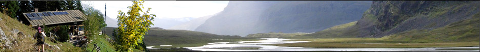


Gîte-auberge »La Maison du Valier« Vallée du Biros / Castillonais
Europa
»
Frankreich
»
Süd-Frankreich
»
Midi-Pyrénées
»
Ariège
»
Les Bordes-sur-Lez
Pyrenäen » Zentral Pyrenäen
Pyrenäen » Zentral Pyrenäen
GPS-Tracks
Folgende GPS-Tracks tangieren diesen Punkt (hier einen Track beginnen):
| Name | Infos | Länge | Höhenm. | Typ |
|---|---|---|---|---|
| Es konnten keine GPS-Tracks gefunden werden. | ||||
Benachbarte Hütten
Im Umkreis von 20km, alle Entfernungen Luftlinie / real, max. 20 Hütten.
| Name | Infos | Entf. | Richt. | Optionen |
|---|---|---|---|---|
| Refuge du Pla de La Lau Vallée du Biros / Castillonais | 0km | S | Karte | |
| Abri du Pla de La Lau Vallée du Biros / Castillonais | 0.2km | NW | Karte | |
| Refuge Pla Lalau Vallée du Biros / Castillonais | 0.3km | NW | Karte | |
| Cabane de l' Artigue Vallée du Biros / Castillonais | 1.4km | W | Karte | |
| Cabane du Trapech du Milieu Vallée du Biros / Castillonais | 1.5km | W | Karte | |
| Refuge Aouen Vallée du Biros / Castillonais | 1.6km | O | Karte | |
| Cabane du Trapech du Haut Vallée du Biros / Castillonais | 1.9km | W | Karte | |
| Abri de Nerech Vallée du Biros / Castillonais | 2km | SSO | Karte | |
| Cabane Courille Castillonais/Bethmale | 2.1km | NO | Karte | |
| Cabane Col de Part Vallée du Biros / Castillonais | 2.2km | W | Karte | |
| Cabane Clot du Lac Vallée du Biros / Castillonais | 2.3km | W | Karte | |
| Cabane du Besset Vallée du Biros / Castillonais | 2.5km | W | Karte | |
| Cabane Taus du Valier Vallée du Biros / Castillonais | 2.6km | O | Karte | |
| Cabane de Peyrade Vallée du Biros / Castillonais | 2.7km | SSW | Karte | |
| Cabane Esclots Vallée du Biros / Castillonais | 2.8km | SW | Karte | |
| Cabane de Tremul Massif du Vallier | 2.9km | SO | Karte | |
| Cabane Lée Castillonais/Bethmale | 3km | NNO | Karte | |
| Refuge Salvador Castillonais/Bethmale | 3.3km | NNO | Karte | |
| Cabane Campuls Castillonais/Bethmale | 3.5km | NO | Karte | |
| Cabane Trinqué Vallée du Biros / Castillonais | 3.5km | SSW | Karte |
Orte in der Nähe
Im Umkreis von maximal 20 km, alle Entfernungen Luftlinie / real, max. 20 Orte.
| Name | PLZ | Entf. | Richt. | Optionen |
|---|---|---|---|---|
| Bethmale | F-? | 5.7km | NO | Karte |
| Uchentein | F-? | 6.4km | NNW | Karte |
| Balacet | F-? | 7.1km | NW | Karte |
| Les Bordes-sur-Lez | F-? | 7.7km | N | Karte |
| Salsein | F-? | 7.8km | N | Karte |
| Arrien-en-Bethmale | F-? | 7.8km | N | Karte |
| Sentein | F-? | 7.8km | WNW | Karte |
| Irazein | F-? | 7.9km | NW | Karte |
| Antras | F-? | 8.9km | WNW | Karte |
| Sor | F-? | 9.6km | N | Karte |
| Castillon-en-Couserans | F-? | 11.4km | N | Karte |
| Audressein | F-? | 11.5km | N | Karte |
| Cescau | F-? | 11.5km | N | Karte |
| Argein | F-? | 11.7km | NNW | Karte |
| Aucazein | F-? | 12.1km | NNW | Karte |
| Illartein | F-? | 12.6km | NNW | Karte |
| Arrout | F-? | 13.3km | N | Karte |
| Couflens | F-? | 13.4km | OSO | Karte |
| Alos | F-? | 13.5km | NO | Karte |
| Engomer | F-? | 13.6km | NNO | Karte |
Achtung: Die Lage der Städte und damit auch die Entfernung ist teils recht ungenau und sollte nur als grober
Anhaltspunkt angesehen werden. Zudem sind die Angaben lediglich als bewohnte
Orte zu verstehen.
Gipfel im Umkreis (Auswahl)
Im Umkreis von maximal 20km, alle Entfernungen Luftlinie / real, max. 50 Gipfel.
| Name | Infos | Höhe | Entf. | Richt. | Optionen |
|---|---|---|---|---|---|
| Pic Blanc | 3330m | 7.6km | W | Karte | |
| Mauberm | 1694m | 10.2km | WSW | Karte | |
| Pico De Moredo | 2760m | 12.5km | S | Karte | |
| Mont Rouch D'espagne | 2864m | 17.8km | SO | Karte | |
| Tuc De L'adosse | 1669m | 19.9km | O | Karte |
Sollten Sie weitere Umkreisdaten benötigen, so können Sie die Umkreissuche ohne Anzahllimit durchführen.
Download der Koordinaten
- Fugawi 3 (inkl. Umkreisdaten) (TXT)
- G7ToWin (inkl. Umkreisdaten) (CSV-Datei)
- GARtrip (inkl. Umkreisdaten) (TXT)
- Google Earth (inkl. Umkreisdaten) (KML Placemark)
- GPS Exchange Format (inkl. Umkreisdaten) (GPX)
- OziExplorer (inkl. Umkreisdaten) (Wegpunkte, v1.1)
Letzte Bearbeitung:
Freitag, 16. August 2013, 17:02 Uhr
Seitenaufrufe: 874
Seitenaufrufe: 874