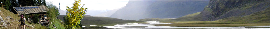


»Gooandra Homestead« north of Kiandra
GPS-Tracks
Folgende GPS-Tracks tangieren diesen Punkt (hier einen Track beginnen):
| Name | Infos | Länge | Höhenm. | Typ |
|---|---|---|---|---|
| Es konnten keine GPS-Tracks gefunden werden. | ||||
Benachbarte Hütten
Im Umkreis von 20km, alle Entfernungen Luftlinie / real, max. 20 Hütten.
| Name | Infos | Entf. | Richt. | Optionen |
|---|---|---|---|---|
| Witzes Hut near Tantangara Dam | 4.3km | OSO | Karte | |
| Hain's Hut west of Tantangara | 6km | NO | Karte | |
| Harveys Hut | 8.3km | SSO | Karte | |
| Kiandra Court House in Kiandra | 8.9km | SW | Karte | |
| Wolgal Lodge in Kiandra | 9km | SW | Karte | |
| Pattinsons Hut | 9.9km | SW | Karte | |
| Sawyers Hill Hut | 10.6km | S | Karte | |
| Millers Hut on Long Plain | 11.2km | NNO | Karte | |
| Long Plain Homestead | 11.5km | N | Karte | |
| Delany's Hut on the side of the Snowy Highway | 12.3km | SSO | Karte | |
| Townsends Lodge east of Tantangara Dam | 13.4km | O | Karte | |
| Washington Arms Hotel | 13.5km | WNW | Karte | |
| Circuits Hut north of Currango | 13.7km | O | Karte | |
| Schofields Hut on the Tantangara Plain | 13.8km | OSO | Karte | |
| Four Mile Hut Kosciuszko National Park | 15.3km | SSW | Karte | |
| Pedens Hut to the east of Tantangara Dam | 15.4km | O | Karte | |
| Hainsworth Hut west of Tantangara Dam | 15.5km | NNO | Karte | |
| Gavels Hut at the southern end of Tantangara Plain | 15.6km | SO | Karte | |
| Currango Homestead on the Eastern side of Tantangara Plain | 16.2km | ONO | Karte | |
| Old Currango Hut at the top of the Tantangara Plain | 16.2km | NO | Karte |
Orte in der Nähe
Im Umkreis von maximal 20 km, alle Entfernungen Luftlinie / real, max. 20 Orte.
| Name | PLZ | Entf. | Richt. | Optionen |
|---|---|---|---|---|
| Tantangara | AUS-? | 3.2km | OSO | Karte |
| Yarrangobilly Caves | AUS-? | 8.2km | NNW | Karte |
| Kiandra | AUS-? | 9.8km | SSW | Karte |
| West Denison | AUS-? | 15.8km | SSO | Karte |
| Yarrangobilly | AUS-? | 17.5km | NNW | Karte |
| Denison | AUS-? | 18.1km | SSO | Karte |
Achtung: Die Lage der Städte und damit auch die Entfernung ist teils recht ungenau und sollte nur als grober
Anhaltspunkt angesehen werden. Zudem sind die Angaben lediglich als bewohnte
Orte zu verstehen.
Gipfel im Umkreis (Auswahl)
Im Umkreis von maximal 20km, alle Entfernungen Luftlinie / real, max. 50 Gipfel.
| Name | Infos | Höhe | Entf. | Richt. | Optionen |
|---|---|---|---|---|---|
| Es konnten keine Gipfel gefunden werden. | |||||
Sollten Sie weitere Umkreisdaten benötigen, so können Sie die Umkreissuche ohne Anzahllimit durchführen.
Download der Koordinaten
- Fugawi 3 (inkl. Umkreisdaten) (TXT)
- G7ToWin (inkl. Umkreisdaten) (CSV-Datei)
- GARtrip (inkl. Umkreisdaten) (TXT)
- Google Earth (inkl. Umkreisdaten) (KML Placemark)
- GPS Exchange Format (inkl. Umkreisdaten) (GPX)
- OziExplorer (inkl. Umkreisdaten) (Wegpunkte, v1.1)
Letzte Bearbeitung:
Mittwoch, 12. Mai 2010, 10:12 Uhr
Seitenaufrufe: 876
Seitenaufrufe: 876