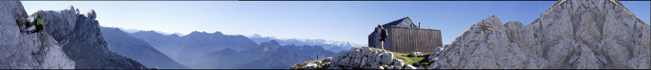


Monte Caio
GPS-Tracks
Folgende GPS-Tracks tangieren diesen Punkt (hier einen Track beginnen):
| Name | Infos | Länge | Höhenm. | Typ |
|---|---|---|---|---|
| Es konnten keine GPS-Tracks gefunden werden. | ||||
Benachbarte Hütten
Im Umkreis von 20km, alle Entfernungen Luftlinie / real, max. 20 Hütten.
| Name | Infos | Entf. | Richt. | Optionen |
|---|---|---|---|---|
| Rifugio Pratizzano in Ramiseto | 12.9km | SO | Karte |
Orte in der Nähe
Im Umkreis von maximal 20 km, alle Entfernungen Luftlinie / real, max. 20 Orte.
| Name | PLZ | Entf. | Richt. | Optionen |
|---|---|---|---|---|
| Agna | I-? | 3.1km | WNW | Karte |
| Isola | I-? | 4.1km | SSO | Karte |
| Sivizzo | I-? | 4.4km | WSW | Karte |
| Anzolla | I-? | 4.4km | ONO | Karte |
| Palanzano | I-? | 4.7km | SO | Karte |
| Corniglio | I-? | 5.2km | W | Karte |
| Carobbio | I-? | 5.5km | N | Karte |
| Monchio delle Corti | I-? | 5.8km | SSW | Karte |
| Lugagnano Superiore | I-? | 5.8km | SSO | Karte |
| Agrimonte | I-? | 6.6km | W | Karte |
| Tizzano Val Parma | I-? | 6.8km | NO | Karte |
| Casarola | I-? | 6.9km | SW | Karte |
| Selvanizza | I-? | 7.7km | OSO | Karte |
| Reno | I-? | 7.8km | NNO | Karte |
| Vairo | I-? | 7.8km | SO | Karte |
| Ranzano | I-? | 8km | O | Karte |
| Castello | I-? | 8.1km | WNW | Karte |
| Pianadetto | I-? | 8.5km | SW | Karte |
| Lugolo | I-? | 9.2km | SO | Karte |
| Signatico | I-? | 9.3km | N | Karte |
Achtung: Die Lage der Städte und damit auch die Entfernung ist teils recht ungenau und sollte nur als grober
Anhaltspunkt angesehen werden. Zudem sind die Angaben lediglich als bewohnte
Orte zu verstehen.
Gipfel im Umkreis (Auswahl)
Im Umkreis von maximal 20km, alle Entfernungen Luftlinie / real, max. 50 Gipfel.
| Name | Infos | Höhe | Entf. | Richt. | Optionen |
|---|---|---|---|---|---|
| Punta Fegni | 1485m | 1.6km | SW | Karte | |
| Groppo Ferniana | 1481m | 1.8km | SW | Karte | |
| La Penna | 1351m | 2.3km | OSO | Karte | |
| Poggio Del Ferro | 1237m | 4km | SW | Karte | |
| Monte Fageto | 1284m | 6.1km | SSO | Karte | |
| Monte Di Vairo | 1236m | 6.7km | SSO | Karte | |
| Monte Matalla | 1243m | 7.1km | SSO | Karte | |
| Monte Ronco Bora | 1228m | 7.5km | S | Karte | |
| Monte Cervellino | 1493m | 9km | WNW | Karte | |
| Il Barcone | 1420m | 9.7km | WNW | Karte | |
| Monte Cavalcalupo | 1370m | 10km | NNW | Karte | |
| Monte Fuso | 1118m | 10.5km | ONO | Karte | |
| Monte Navert | 1654m | 10.7km | SW | Karte | |
| Monte Castagnole | 1259m | 11.4km | WNW | Karte | |
| Groppo Albero | 1386m | 11.9km | W | Karte | |
| Rocca Pumaciolo | 1714m | 12.4km | SW | Karte | |
| Monte Tavola | 1508m | 12.6km | WSW | Karte | |
| Roccabiasca | 1730m | 12.8km | WSW | Karte | |
| Monte Ledo | 1322m | 13km | SSO | Karte | |
| Monte Sillara | 1859m | 13.2km | SW | Karte | |
| Monte Fosco | 1682m | 13.2km | WSW | Karte | |
| Monte Matto | 1836m | 13.5km | SW | Karte | |
| Monte Losanna | 1856m | 13.6km | SW | Karte | |
| Monte Brusa | 1794m | 13.9km | WSW | Karte | |
| Monte Fontanini | 1400m | 14km | W | Karte | |
| Monte Orsaro | 1830m | 14.1km | WSW | Karte | |
| Monte Acuto | 649m | 14.1km | ONO | Karte | |
| Groppo Del Vescovo | 1248m | 14.2km | W | Karte | |
| Monte Aquila | 1775m | 14.2km | WSW | Karte | |
| Monte Bocco | 1771m | 14.3km | SSW | Karte | |
| Monte Marmagna | 1852m | 14.5km | WSW | Karte | |
| Monte Braiola | 1818m | 14.5km | WSW | Karte | |
| Monte Ventasso | 1728m | 15km | SO | Karte | |
| Monte Federici | 1371m | 15.1km | SW | Karte | |
| Punta Buffanaro | 1882m | 15.8km | S | Karte | |
| Cimarola | 1148m | 15.8km | SW | Karte | |
| Monte Casarola | 1979m | 15.8km | SSO | Karte | |
| Monte Alarola | 1004m | 16.2km | SW | Karte | |
| Monte Alto | 1904m | 16.6km | S | Karte | |
| Alpe di Succiso | 2017m | 18.8km | S | Karte | |
| Monte la Pinota | 1155m | 19.3km | WNW | Karte | |
| Monte Grotta Mora | 1421m | 19.8km | WNW | Karte |
Sollten Sie weitere Umkreisdaten benötigen, so können Sie die Umkreissuche ohne Anzahllimit durchführen.
Download der Koordinaten
- Fugawi 3 (inkl. Umkreisdaten) (TXT)
- G7ToWin (inkl. Umkreisdaten) (CSV-Datei)
- GARtrip (inkl. Umkreisdaten) (TXT)
- Google Earth (inkl. Umkreisdaten) (KML Placemark)
- GPS Exchange Format (inkl. Umkreisdaten) (GPX)
- OziExplorer (inkl. Umkreisdaten) (Wegpunkte, v1.1)
Letzte Bearbeitung:
Unbekannt
Seitenaufrufe: 100
Seitenaufrufe: 100