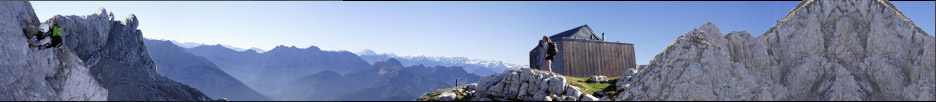


Wahshilas S32
Nordamerika
»
Kanada
»
British Columbia
»
British Columbia Coast South
»
Silverthrone
»
Silverthrone
Nordamerikanische Gebirge (TODO)
Nordamerikanische Gebirge (TODO)
GPS-Tracks
Folgende GPS-Tracks tangieren diesen Punkt (hier einen Track beginnen):
| Name | Infos | Länge | Höhenm. | Typ |
|---|---|---|---|---|
| Es konnten keine GPS-Tracks gefunden werden. | ||||
Benachbarte Hütten
Im Umkreis von 20km, alle Entfernungen Luftlinie / real, max. 20 Hütten.
| Name | Infos | Entf. | Richt. | Optionen |
|---|---|---|---|---|
| Es konnten keine Hütten gefunden werden. | ||||
Orte in der Nähe
Im Umkreis von maximal 45 km, alle Entfernungen Luftlinie / real, max. 20 Orte.
| Name | PLZ | Entf. | Richt. | Optionen |
|---|---|---|---|---|
| Kingcome Inlet | CDN-? | 24.6km | WNW | Karte |
| Knight Inlet | CDN-? | 25km | SSO | Karte |
| Jackson Bay | CDN-? | 41.5km | SSO | Karte |
| Minstrel Island | CDN-? | 43.3km | WSW | Karte |
Achtung: Die Lage der Städte und damit auch die Entfernung ist teils recht ungenau und sollte nur als grober
Anhaltspunkt angesehen werden. Zudem sind die Angaben lediglich als bewohnte
Orte zu verstehen.
Gipfel im Umkreis (Auswahl)
Im Umkreis von maximal 20km, alle Entfernungen Luftlinie / real, max. 50 Gipfel.
| Name | Infos | Höhe | Entf. | Richt. | Optionen |
|---|---|---|---|---|---|
| Wahshilas S38 | 1579m | 6.2km | SSO | Karte | |
| Wahshilas S27 | 1885m | 7.2km | NO | Karte | |
| Wahshilas S39 | 1682m | 7.6km | SW | Karte | |
| Wahshilas S31 | 1785m | 8km | ONO | Karte | |
| Wahshilas S36 | 1841m | 8km | W | Karte | |
| Wahshilas S40 | 1602m | 8.3km | S | Karte | |
| Wahshilas S33 | 1652m | 9.2km | WNW | Karte | |
| Wahshilas S42 | 1483m | 9.8km | SSW | Karte | |
| Wahshilas SW32 | 1650m | 10.7km | WNW | Karte | |
| Wahshilas S37 | 1411m | 10.7km | W | Karte | |
| Wahshilas SW36 | 1451m | 12.3km | W | Karte | |
| Wahshilas SW31 | 1656m | 13km | WNW | Karte | |
| Wahshilas S41 | 1347m | 13.8km | WSW | Karte | |
| Wahshilas SW33 | 1513m | 13.9km | WNW | Karte | |
| Wahshilas SW40 | 1364m | 14.5km | W | Karte | |
| Wahshilas SW39 | 1285m | 14.7km | W | Karte | |
| Wahshilas S18 | 1981m | 14.8km | N | Karte | |
| Wahshilas S43 | 1410m | 15.8km | WSW | Karte | |
| Mount Prideaux | 1548m | 16km | SSW | Karte | |
| Beatrice Peak | 1347m | 16.8km | S | Karte | |
| Mount Hills | 1791m | 16.8km | ONO | Karte | |
| Everard SE5 | 1984m | 17.6km | NO | Karte | |
| Mount Wood | 1718m | 17.8km | ONO | Karte | |
| Smyth Cone | 1602m | 19.1km | WNW | Karte | |
| Wahshilas SW32 | 1798m | 19.5km | WNW | Karte | |
| Mount Everard | 2195m | 19.7km | NO | Karte | |
| Wahshilas S13 | 1991m | 19.8km | N | Karte |
Sollten Sie weitere Umkreisdaten benötigen, so können Sie die Umkreissuche ohne Anzahllimit durchführen.
Download der Koordinaten
- Fugawi 3 (inkl. Umkreisdaten) (TXT)
- G7ToWin (inkl. Umkreisdaten) (CSV-Datei)
- GARtrip (inkl. Umkreisdaten) (TXT)
- Google Earth (inkl. Umkreisdaten) (KML Placemark)
- GPS Exchange Format (inkl. Umkreisdaten) (GPX)
- OziExplorer (inkl. Umkreisdaten) (Wegpunkte, v1.1)
Letzte Bearbeitung:
Unbekannt
Seitenaufrufe: 251
Seitenaufrufe: 251